Umweltschutz Links
  • Communities
  • Create Post
  • heart
    Support Lemmy
  • search
    Search
  • Login
  • Sign Up
boredsquirrel@slrpnk.net to Geography@mander.xyzEnglish · 1 year ago

True continent sizes

slrpnk.net

message-square
21
fedilink
55

True continent sizes

slrpnk.net

boredsquirrel@slrpnk.net to Geography@mander.xyzEnglish · 1 year ago
message-square
21
fedilink
alert-triangle
You must log in or register to comment.
  • mad_asshatter@lemmy.world
    link
    fedilink
    English
    arrow-up
    15
    ·
    1 year ago

    All those countries are in-continent.

    • ironhydroxide@sh.itjust.works
      link
      fedilink
      English
      arrow-up
      10
      ·
      1 year ago

      Except for the one with Europe. It’s semi-continent in-continent

  • disguy_ovahea@lemmy.world
    link
    fedilink
    English
    arrow-up
    8
    arrow-down
    1
    ·
    1 year ago

    www.thetruesize.com is a fun interactive website for seeing how Mercator maps lie.

    • NaibofTabr@infosec.pub
      link
      fedilink
      English
      arrow-up
      11
      ·
      1 year ago

      What’s your preferred projection?

      To say that Mercator “lies” is to misrepresent the complications of projecting a 3 dimensional object onto a 2 dimensional surface. All projections “lie” in this sense because they’re simplifications of reality - that’s what a map is.

      • Grubberfly 🔮@mander.xyz
        link
        fedilink
        English
        arrow-up
        1
        ·
        10 months ago

        this video is based on the comic: it’s an animation on how each projection would change when shifted.

      • disguy_ovahea@lemmy.world
        link
        fedilink
        English
        arrow-up
        1
        arrow-down
        1
        ·
        1 year ago

        A globe, Apple Maps, or Google Earth

        • NaibofTabr@infosec.pub
          link
          fedilink
          English
          arrow-up
          2
          ·
          1 year ago

          Yes, you’re very clever.

          This isn’t an answer, it’s a dodge.

          • disguy_ovahea@lemmy.world
            link
            fedilink
            English
            arrow-up
            1
            arrow-down
            1
            ·
            1 year ago

            Mercator is the most accessible paper map. The Authagraph is the most accurate due to low distortion. It’s not listed in the comic, and can be confusing to use as a learning tool.

            The real question is why are you so committed to flat maps in the digital age? I don’t even understand why Google Maps doesn’t correct to a spheroid when zoomed out like Apple Maps, requiring users to download Google Earth for accurate representation of land mass size comparison.

  • Patapon Enjoyer@lemmy.world
    link
    fedilink
    English
    arrow-up
    5
    ·
    edit-2
    1 year ago

    I think the contiguous US like in the picture is more like 8m km² isn’t it? 9.8 must be counting Alaska, Hawaii and maybe the territories.

  • milicent_bystandr@lemm.ee
    link
    fedilink
    English
    arrow-up
    4
    ·
    edit-2
    1 year ago

    I don’t like that Russia looks like they just took a Mercator projection and shrank to scale. Because of its shape and location, Russia is especially distorted by the Equatorial-centred Mercator.

    Also what’s with the “excluding Russia” footnote?

    • boredsquirrel@slrpnk.netOP
      link
      fedilink
      English
      arrow-up
      4
      ·
      edit-2
      1 year ago

      Europe without the part of russia that lies on the continent.

      But true, Russia at the equator looks like this:
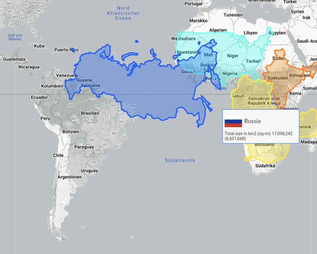
      • acockworkorange@mander.xyz
        link
        fedilink
        English
        arrow-up
        3
        ·
        1 year ago

        A galloping sheep.

    • towerful@programming.dev
      link
      fedilink
      English
      arrow-up
      3
      ·
      1 year ago

      Ah, I see. It’s Europe *

  • wreckedcarzz@lemmy.world
    link
    fedilink
    English
    arrow-up
    2
    ·
    1 year ago

    As opposed to the False Size of Africa

    • grrgyle@slrpnk.net
      link
      fedilink
      English
      arrow-up
      4
      arrow-down
      1
      ·
      1 year ago

      Literally what the Mercator projection is

  • Patrizsche@lemmy.ca
    link
    fedilink
    English
    arrow-up
    1
    ·
    1 year ago

    I mean, it’s a continent

Geography@mander.xyz

geography@mander.xyz

Subscribe from Remote Instance

Create a post
You are not logged in. However you can subscribe from another Fediverse account, for example Lemmy or Mastodon. To do this, paste the following into the search field of your instance: !geography@mander.xyz

Welcome to c/Geography @ Mander.xyz!


Geography is just physics slowed down, with a couple of trees stuck in it. - Terry Pratchett


Notice Board

  • 2023-06-13: We are looking for mods. Send a dm to @fossilesque@mander.xyz if interested! This is a work in progress, please don’t mind the mess.


Geography is the study of places and the relationships between people and their environments. Geographers explore both the physical properties of Earth’s surface and the human societies spread across it. They also examine how human culture interacts with the natural environment and the way that locations and places can have an impact on people. Geography seeks to understand where things are found, why they are there, and how they develop and change over time. Read more…

Rules

  1. Don’t throw mud. Be kind and remember the human.
  2. Keep it rooted (on topic).
  3. No spam.


Quick Links

  • What is geography?
  • What is climate change and how do we know it is real?
  • What can you do about climate change?

-

Links

News & Publications

  • Eos.org

Resources

  • List of Professional Organisations
  • List of personal actions and resources you can use to help combat climate change.
  • Academics on Mastodon
  • Inclusive Fieldwork
  • The ‘publishing and getting read’ guide for researchers in geography - RGS


Similar Communities

  • !geology@lemmy.ca
  • !geophysics@lemmy.ca
  • !geologycareers@lemmy.ca
  • !mining@lemmy.ca
  • !openscience@lemmy.ml

Sister Communities

Science and Research

  • !scicomm@mander.xyz

Biology and Life Sciences

  • !anthropology@mander.xyz
  • !biodiversity@mander.xyz
  • !palaeoecology@mander.xyz
  • !palaeontology@mander.xyz

Plants & Gardening

  • !balconygardening@slrpnk.net
  • !gardening@mander.xyz
  • !houseplants@mander.xyz
  • !plantid@mander.xyz

Physical Sciences

  • !earthscience@mander.xyz
  • !geography@mander.xyz
  • !geospatial@mander.xyz
  • !soilscience@slrpnk.net

Humanities and Social Sciences

  • !archaeology@mander.xyz
  • !folklore@mander.xyz
  • !history@mander.xyz
  • !old_maps@mander.xyz

Memes

  • !bushrat_confidential@slrpnk.net
  • !science_memes@mander.xyz

Find us on Reddit!

  • r/biogeography
  • r/physicalgeography

Visibility: Public
globe

This community can be federated to other instances and be posted/commented in by their users.

  • 1 user / day
  • 1 user / week
  • 1 user / month
  • 3 users / 6 months
  • 0 local subscribers
  • 0 subscribers
  • 78 Posts
  • 46 Comments
  • Modlog
  • mods:
  • fossilesque@mander.xyz
  • SciBot@mander.xyz
  • BE: 0.19.8
  • Modlog
  • Instances
  • Docs
  • Code
  • join-lemmy.org