Lvxferre [he/him]

The catarrhine who invented a perpetual motion machine, by dreaming at night and devouring its own dreams through the day.

  • 0 Posts
  • 8 Comments
Joined 1 year ago
cake
Cake day: January 12th, 2024

help-circle

  • That’s what happens when a crowd of bloody muppets, who: don’t understand science, refuse to learn about it, refuse to understand what specialists are talking about, take conclusions from a mix of wishful belief + assumptions + pulp fiction, manages to get one of themselves in power. And if anything it proves to me that stupidity is worse than malice.

    Like, let’s pretend for a moment that they totally resurrected the dire wolf, instead of editing a few grey wolf genes and calling it a day. And let’s pretend that this strategy would be viable for multiple species, even dinos. You’re still doing a lot more effort to resurrect a species than to just keep it alive, you know? The efficient strategy here is to protect those species.

  • Just for clarification, because of the title, they’re talking about the upper basin of the Paraguay river:

    As the map shows, and the article mentions later on, that basin is controlled by three governments (the republic of Paraguay, Bolivia, and Brazil).

    That said: global warming-wise the situation here in South America is noticeably bad - summers are getting noticeably harsher and there’s something weird going on with the winds, as if they lost power. It reached a point that it affects humans, so of course it’ll affect amphibians, that are far more environment-sensitive.

    Deforestation of that basin is also a big concern. It’s happening in territory controlled by each of the three governments - Bolivia, Paraguay and Brazil. It’s mostly about cattle - either grazing lands or soya to feed the cattle. And perhaps not surprisingly not to attend the internal markets, but to export it to lands controlled by governments that won’t need to deal with the environmental impact.


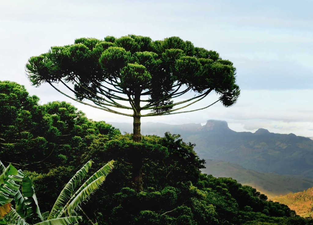
  • The border between Paraná and Santa Catarina (1921 name: Santa Catharina) is wrong for the date. The current border was defined in 1916, in the Contestado War:

    The city I arrowed in both maps is the same (Mangueirinha), note how the map in the OP assigns it to Santa Catarina.

    The borders would be accurate for pre-1916 times if the map didn’t automatically assign the contested region solely to Santa Catarina:

    Climate map is also slightly incorrect for Paraná; there should be a yellow blob around Curitiba (1921 name: Curityba), as the historical average is 17.8°C, or 64°F. The reason for that can be seen in the physical map, it’s in the middle of a rather tall plateau.

    The city called “Iguassu” (near the Paraguayan border) had its name changed already back in 1918, to the contemporary Foz do Iguaçu.

    The Paraguayan city labelled “Azara” is not Azara at all; it’s Ciudad del Este (1921 name: Puerto Presidente Stroessner). Azara is up south, in Misiones (Argentina), bordering Corrientes.

    The Paraguayan-Bolivian border seems accurate for the time though, as this would’ve happened before the Chaco War (1932-5). Eventually that disputed territory would end mostly under Paraguayan control, with Paraguay relinquishing the claims to the small strip left under Bolivian control.


    Sorry for the oddly specific corrections. I know that it’s an old map, being posted for the sake of curiosity; and that by then info was rather slow to go back and forth, so a lot of those errors are understandable. Still… I need to sperg out about my homeland at least once in a while :3

    John Mary the Monk is coming. He’ll lead us to the Celestial Monarchy.